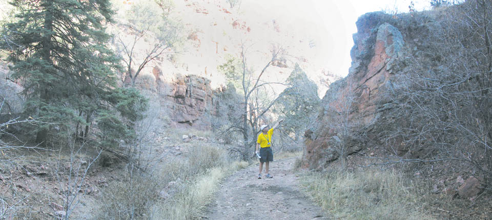
 Standing next to the Camp Creek channel, Tim Mitros, city stormwater engineering manager, points to a rock face in Queen's Canyon that will be used in securing a canyon-spanning metal rack to catch large debris in floods. Westside Pioneer photo
|
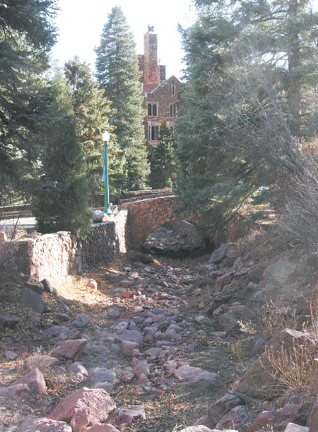 Less than a quarter-mile downstream, the creek channel passes the historic Glen Eyrie castle. Westside Pioneer photo
|
Those drainages are
At a cost of $616,000, by far the biggest of the four planned projects is in Lower Camp Creek. The construction will be in Queen's Canyon, a half mile or less above the Glen Eyrie castle complex, which was built in the late 1800s by Colorado Springs founder William Palmer north of the Garden of the Gods off North 30th Street.
The work will be in the part of the canyon owned by the nonprofit Navigators Christian organization. The Navigators have been working with the city and flood-control consultants on plans to install one or two ōdebris racksö - custom-built steel-cage structures that in this case will span the width of the canyon and stop large objects such as boulders and trees from washing down in a flood, according to Tim Mitros, the city's engineering development review and stormwater manager; and Derek Strickler, direction of operations for the Navigators.
Such racks will not only protect the Navigators' 800 acres, but also downstream properties, including the Garden of the Gods, Rock Ledge and Pleasant Valley. The latter neighborhood is bisected by Camp Creek flowing in a concrete-lined ditch down the middle of 31st Street. ōThat's the big point we want to make,ö Strickler said. ōWe're just the first stop on the journey. Anything we catch there [in the canyon] prevents it from going down 31st Street.ö
Seventy-five percent of the $616,000 cost is being covered by a grant from the U.S. Department of Agriculture's Natural Resources Conservation Service (NRCS) and its Emergency Watershed Protection Program (EWP). The EWP was created by Congress to respond to emergencies caused by natural disasters.
The Navigators are fundraising the grant's 25 percent local ōmatchö ($154,000). The 18,000-acre Waldo fire burned very little of the Navigators land - all but 4,000 of the acres was on U.S. Forest Service land. But the blaze was very intense in the Camp Creek drainage just a mile up the canyon, and other burn areas can be seen on the tops of ridges above Glen Eyrie. Most of that scorched land drains into Queen's Canyon, Strickler noted.
One idea had been to put the racks on the Forest Service property, which starts less than a half-mile up the canyon. But the Forest Service did not want racks on public land, Mitros said.
Strickler said the Navigators are OK with the racks on their land, even though the fundraising is hard work. His organization believes it has a responsibility ōas a good neighborö to those downstream, he said.
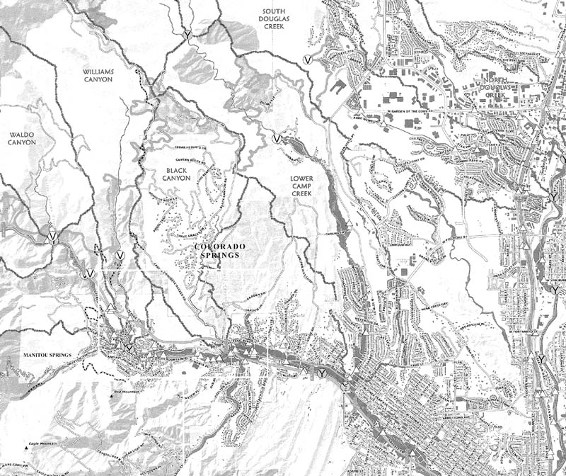 Two drainages of concern to city stormwater engineers because of the Waldo Canyon Fire flow out of the mountains and into the Westside - Camp Creek and South Douglas Creek. A "V" means a calculation point in the U.S. Forest Service's BAER study, a "Y" represents a stream confluence, and a triangle is a potential drainage choke point. The beaded boundary lines display ridge lines separating drainages. The thicker, squiggly lines stand for the boundary of the 18,000-acre fire. A separate set of projects are being planned by El Paso County for Fountain Creek up Ute Pass. Courtesy of Colorado Springs Engineering and Tim Mitros
|
To be effective in Queen's Canyon, a rack must span it from wall to wall, Mitros noted. The anticipated size in this case is 20 feet high and about 80 feet wide. They will be built on site.
Strickler described debris racks as a ōcost-effective, environmentally friendly way to deal with debris.ö Unlike concrete structures, he added, racks ōcan be taken down and you can maintain them and clean out behind them.ö
As for the water itself, the Navigators have taken steps to flood-proof the castle buildings. But constructing a dam or major diversion structures would be ōcost prohibitive,ö Strickler said, adding that a debris rack can at least ōslow the velocityö of the water.
One rack location, less than a quarter-mile upstream from the castle, has been decided on. A second location being considered is in an area of the canyon above a catch basin/water intake (originally built by Palmer) just below the Forest Service property line.
Mitros explained that in other drainages with flood concerns, an alternative solution is to simply excavate a large hole (about 20 feet deep) that can catch debris and also slow floodwaters. But digging like this is not possible in Queen's Canyon because the canyon floor is at bedrock, he said.
The other three grant-supported projects on the Westside are:
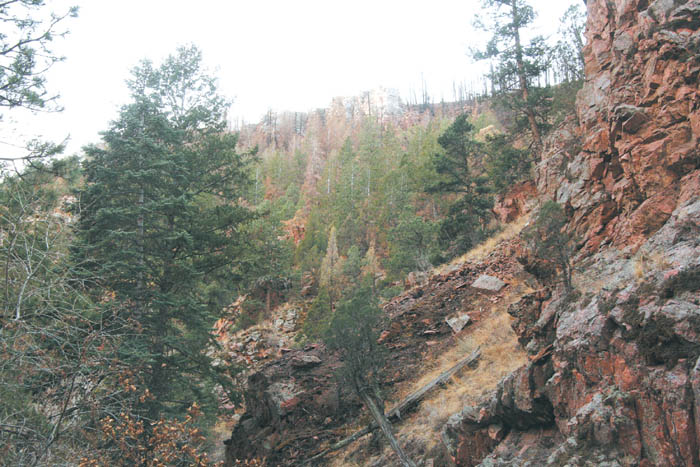 Looking up from Queen's Canyon, the skeletal remains of pine trees on the ridge top, burned in the Waldo Canyon Fire last summer, provide reminders of why flooding concerns have escalated for Camp Creek. Westside Pioneer photo
|
The costs of both South Douglas projects are being covered by a Fire Relief Fund established by the Denver Foundation, with city stormwater engineers and NRCS collaborating on the designs, Mitros said.
In all, flood-related projects with a total value of $11.4 million have been identified that are the responsibility of the city and eligible for 75 percent NRCS funding. Grant applications are in the works for these funds, he said.
Separate from that is a $425,000 study of long-term needs in the Waldo burn area by a private firm called Wildland Hydrology, which had previously helped with mitigation and drainage stabilization after the Hayman Fire. According to Mitros, the study's planned finish time frame is April, with several different entities chipping in on the cost (Colorado Springs, El Paso County, Colorado Department of Transportation, Colorado Springs Utilities, the Colorado Water Conservation Board and the U.S. Forest Service).
Westside Pioneer article