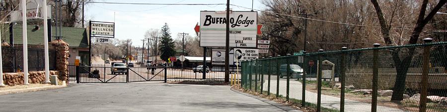
 A wide-angle view from inside the Garden of the Gods RV Resort looks east toward Colorado Avenue. At far left is a medical marijuana store (on the same site as the "Adams Crossing Grocery" at far right in the photo below, facing the opposite direction). At left, a westbound vehicle drives up to Columbia Road on what engineers are calling the avenue's "slip ramp" (once a streetcar right of way). At right, on the other side of the resort's green fence, is the Midland Trail. Farther right are the concrete walls of the avenue's bridge over Fountain Creek. Built in 1934, the bridge's replacement is part of the project. The "preferred alignment" would shift the avenue slightly north, with the new bridge being built just north of the current one. This would require realigning the trail access and obtaining some of the property next to it from the resort owners, according to the Westside Avenue Action Plan's project team. Westside Pioneer photo
|
Westside Avenue Plan's Bridge-to-Ridge 'preferred alignment' would move bridge and avenue north
A “preferred alignment” that shifts part of Colorado Avenue slightly to the north will be presented Wednesday, April 16 at the next public meeting on the Westside Avenue Action Plan (WAAP).Also on the list for the meeting, scheduled from 5:30 to 7 p.m. at the Westside Community Center, 1628 W. Bijou St., is an explanation of plans for the new bridge over Fountain Creek at Columbia Road, which would be built just north of the current one and five feet higher.
The greater height would help in a potential flood, while building it “off-line,” as County Engineer Andre Brackin put it, would allow traffic to continue moving over the current bridge while construction is going on.
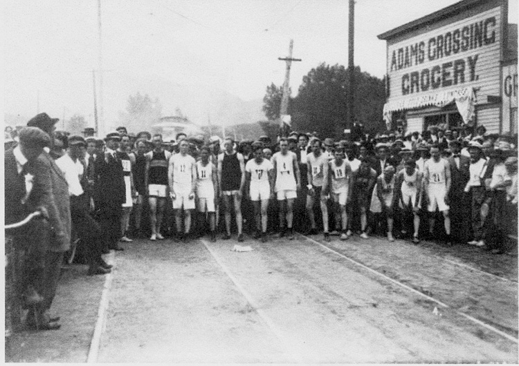 A photo shot in 1913, looking west, shows a footrace about to start on what engineers now call the "slip ramp" off westsbound Colorado Avenue coming up to Columbia Road. The Adams Crossing Grocery at right is on the same site as the medical marijuana store today (at far left in the photo above the headline, facing the opposite way). The store took its name from Charles Adams, a Civil War veteran, prominent local businessman, Indian agent and one-time ambassador to Bolivia who had lived nearby until his death in 1895. The streetcar line can be seen in the roadbed. The line continued along the north side of Fountain Creek (its former right of way is used by the Midland Trail). Historian Mel McFarland has identified the large vehicle in the background (behind the runners) as a streetcar. Courtesy of Tom Daniels, from the Old
Colorado City Historical Society Archives
|
WAAP is a study involving El Paso County, Colorado Springs and Manitou Springs to decide how to spend $16 million on public improvements to the avenue west of 31st Street. Funding has been approved from the Pikes Peak Rural Transportation Authority and the Colorado Department of Transportation, with work expected to start in 2015.
In an interview this week, County Engineer Andre Brackin said the plan is still conceptual, but he expects the avenue's northward shift would be about 10 feet. This would be east of Columbia to about 36th Street. The project team is calling this the “preferred alignment.”
For roughly the first 100 feet east of Columbia, the roadway is already wider -- a carryover from the early 1900s when the streetcar line approaching the bridge west along the avenue veered northwest before the bridge. It was joined at that point back then by the Denver & Rio Grande railroad line between Colorado Springs and Manitou. Their shared right of way west of Columbia is now the Midland Trail. See separate Westside Pioneer article).
If any private property must be taken on the north side, it would only be “small amounts,” not full parcels, Brackin said. Giving the project team road-width flexibility is a previous engineering decision (following a series of public meetings that started in 2012) to change the layout from the current two lanes each way without turn lanes to one lane each way with a center lane.
Under the preferred alignment, the biggest property taking would likely be needed for the new bridge over Fountain Creek. Currently just north of the current bridge, along with the Midland Trail access, is the entrance to the Garden of the Gods RV Resort. The trail access could be relocated, and discussions are continuing with the resort owners, Brackin said.
Barry Grossman of Bachman PR (one of the subconsultants), elaborated that all the potentially affected property owners in that area have been contacted, and “to a person they found no fatal flaws with what's being suggested.” This includes the resort owners, he said: “They understand the need.”
Other potential Bridge-to-Ridge discussion topics at the April 16 meeting include the bridge's appearance (for example, contemporary or historical), changes needed to the Colorado/Ridge intersection, whether to provide bike lanes, a route for the Midland Trail and what can happen with the leftover right of way on the south side of the avenue.
On the latter issue, Brackin said that some of that right of way could go to Amanda's Fonda restaurant so it can offer more off-street parking spaces.
For more information, the project team can be contacted at 629-7566 or info@westsideavenueplan.com.
Westside Pioneer article
(Posted 4/10/14;
Projects: No Man's Land)
Would you like to respond to this article? The Westside Pioneer welcomes letters at editor@westsidepioneer.com. (Click here for letter-writing criteria.)